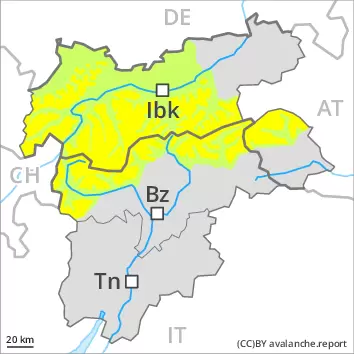
Wind slabs at high altitudes and in high Alpine regions. Wet avalanches as the day progresses.
The fresh wind slabs of the weekend are in some cases still prone to triggering. They are to be evaluated with care and prudence in particular on steep shady slopes above approximately 2600 m. The avalanche prone locations are to be found adjacent to ridgelines and in gullies and bowls. The number and size of avalanche prone locations will increase with altitude. The wind slabs are to be avoided in particular in very steep terrain.
From midday as a consequence of warming during the day and solar radiation there will be a gradual increase in the danger of wet avalanches. On extremely steep slopes natural loose snow slides are to be expected, especially in case of releases originating from sunny starting zones.
Snowpack
dp.10: springtime scenario dp.6: cold, loose snow and wind
Over a wide area 10 to 20 cm of snow, and even more in some localities, has fallen since Friday above approximately 2000 m. The sometimes storm force wind has transported the new snow and, in some cases, old snow as well. The fresh wind slabs have settled a little. They are in some cases still prone to triggering at elevated altitudes.
On Monday it will be very mild. Sunshine and high temperatures will give rise as the day progresses to gradual softening of the snowpack.
Tendency
The conditions are spring-like. The weather will be very mild. Increase in danger of wet avalanches as a consequence of warming during the day and solar radiation.
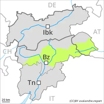
AM Danger level
PM Danger level
2400m
Avalanche Problem
Wet snow
2400m
Wet avalanches as the day progresses.
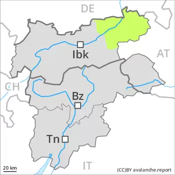
The early morning will see quite favourable conditions. The mostly small wind slabs of the weekend are now only very rarely prone to triggering. Individual avalanche prone locations are to be found on very steep shady slopes at elevated altitudes. The wind slabs are clearly recognisable.
As a consequence of warming during the day and solar radiation there will be a gradual increase in the danger of wet avalanches. On extremely steep slopes moist loose snow slides are to be expected. Mostly avalanches are only small.
Snowpack
dp.10: springtime scenario
On Monday it will be very mild. Sunshine and high temperatures will give rise as the day progresses to gradual softening of the snowpack. The rather small wind slabs of the weekend have bonded quite well with the old snowpack.
Tendency
The conditions are spring-like. Increase in danger of wet avalanches as a consequence of warming during the day and solar radiation.
AM Danger level
2400m
Avalanche Problem
Wind-drifted snow
2400m
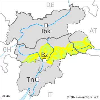
PM Danger level
2400m
Avalanche Problem
Wet snow
2400m
Wind-drifted snow
2400m
Wet avalanches as the day progresses.
The early morning will see quite favourable conditions mostly. From midday as a consequence of warming during the day and solar radiation there will be a gradual increase in the danger of wet avalanches. On extremely steep slopes moist snow slides and avalanches are possible. Mostly avalanches are only small. The wind slabs of the weekend are in individual cases still prone to triggering. They are to be evaluated with care and prudence at elevated altitudes. These are clearly recognisable.
Snowpack
dp.10: springtime scenario dp.6: cold, loose snow and wind
On Monday it will be very mild. Sunshine and high temperatures will give rise as the day progresses to gradual softening of the snowpack. The wind slabs have bonded quite well with the old snowpack. They are in some cases still prone to triggering at elevated altitudes. These are mostly only small.
Tendency
The conditions are spring-like. Increase in danger of wet avalanches as a consequence of warming during the day and solar radiation.
AM Danger level
2600m
Avalanche Problem
Wind-drifted snow
2600m
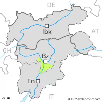
PM Danger level
2400m
Avalanche Problem
Wet snow
2400m
Wind-drifted snow
2600m
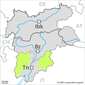
The early morning will see favourable conditions generally, but the danger of wet avalanches will increase later.
The early morning will see quite favourable conditions mostly. The clearly visible wind slabs of the weekend are in individual cases still prone to triggering in particular on steep shady slopes above approximately 2600 m. Mostly avalanches are only small. Wind slabs are to be bypassed especially in terrain where there is a danger of falling.
During the day: From midday as a consequence of warming during the day and solar radiation there will be an increase in the danger of wet avalanches. On extremely steep sunny slopes natural loose snow slides are possible.
Snowpack
dp.10: springtime scenario dp.6: cold, loose snow and wind
The wind slabs have bonded quite well with the old snowpack. They are in individual cases still prone to triggering at elevated altitudes.
On Monday it will be very mild. Sunshine and high temperatures will give rise as the day progresses to gradual softening of the snowpack. The new snow of the weekend can be released naturally in particular on extreme sunny slopes.
Tendency
The conditions are spring-like. Increase in danger of wet avalanches as a consequence of warming during the day and solar radiation.
AM Danger level
PM Danger level
2600m
Avalanche Problem
Wet snow
2600m
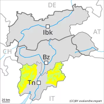
The conditions are spring-like. Wet snow requires caution.
The early morning will see favourable conditions generally. From midday as a consequence of warming during the day and solar radiation there will be a gradual increase in the danger of wet snow slides. The wind slabs of the weekend are now only very rarely prone to triggering.
Snowpack
dp.10: springtime scenario
In all aspects as well as in all altitude zones only a little snow is now lying. The surface of the snowpack has frozen to form a strong crust and will soften during the day. The wind slabs have bonded well with the old snowpack.
Tendency
The conditions are spring-like. Slight increase in danger of moist snow slides as a consequence of warming during the day and solar radiation.
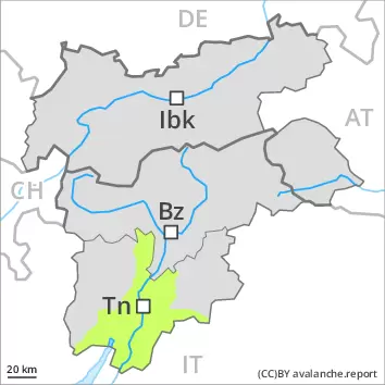
Danger level
1800m
Avalanche Problem
Wet snow
1800m
As a consequence of the solar radiation, the likelihood of moist and wet avalanches being released will increase gradually in particular on steep shady slopes above approximately 2000 m.
The high temperatures as the day progresses will give rise to increasing moistening of the snowpack in all aspects. These conditions will facilitate a gradual weakening of the near-surface layers as the day progresses in particular on shady slopes. On southeast, south and southwest facing slopes no snow is lying. Above approximately 1800 m small moist and wet avalanches are possible.
Snowpack
dp.10: springtime scenario
As a consequence of mild temperatures and solar radiation the snowpack consolidated. The surface of the snowpack is frozen, but not to a significant depth and will already soften in the late morning. The old snowpack remains weakly bonded especially on very steep shady slopes.
Tendency
The conditions are spring-like. Slight increase in danger of moist snow slides as a consequence of warming during the day and solar radiation.